Introduction
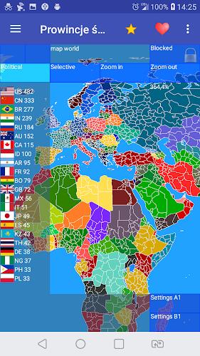
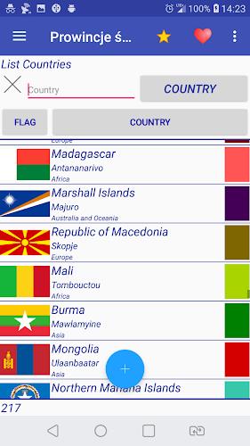
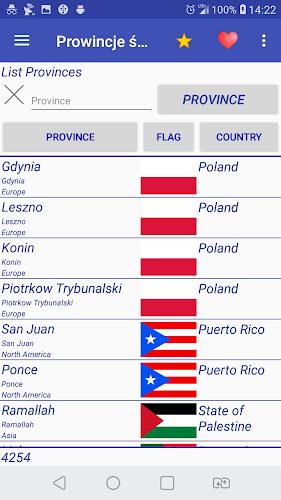
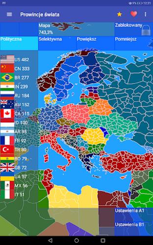
World Provinces is a map-driven simulation and design tool that puts provincial detail at the center of every scenario. World Provinces gives you a high-resolution global canvas with over 4,440 provinces and support for 210+ nations, letting historians, educators and strategy enthusiasts redraw borders, craft nations and experiment with large-scale geopolitical simulations. Whether you want to reconstruct a historical period, design an alternative timeline or build a classroom-ready scenario, World Provinces combines precise editing tools with flexible simulation controls to make detailed world-building accessible.
Core features and what you can do
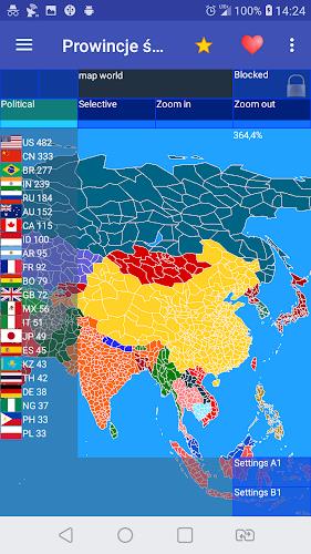
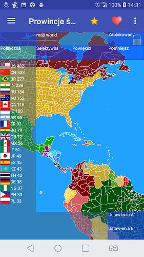
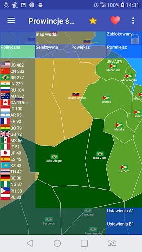
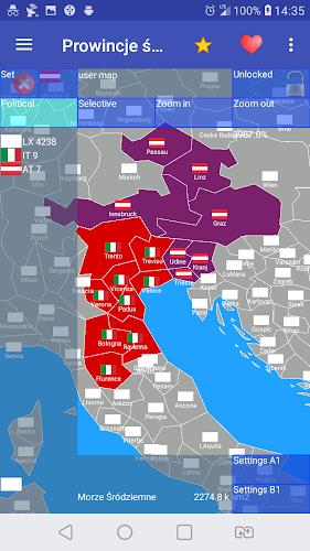
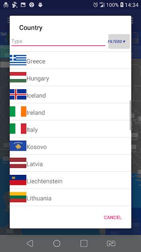
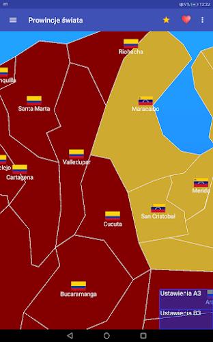
The app provides a full suite of editors for territory, identity and insignia. Use the territory editor to assign provinces to nations, adjust provincial attributes and set diplomatic status. The built-in flag and symbol editor allows layered emblem creation so each nation carries a unique visual identity. Historical reconstruction tools include editable time-slice templates that help you begin from commonly studied eras; alternative-history mode lets you branch from those templates to test “what if” outcomes. Scenario files are saved locally for sharing or archiving, and the app supports importing and exporting scenario packages for collaboration outside the app environment.
Gameplay mechanics and simulation controls
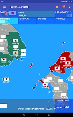
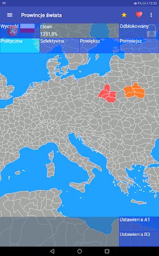
Gameplay in World Provinces centers on province-level management and simulation parameters rather than tactical combat. Simulation controls let you toggle time step speed, enable or disable automated border pressure effects, and set regional stability variables that influence migration or unrest. Scenario designers can place scripted events or triggers that modify resource levels, diplomatic relations or provincial loyalty when conditions are met. These mechanics create a sandbox where policy choices, border changes and disaster events produce measurable shifts across the map without requiring real-time reflexes.
Touch controls, editing workflow and accessibility
The interface is optimized for touch and stylus use: pinch to zoom, two-finger pan, tap to select provinces and long-press for context actions like bulk assignment or attribute editing. A layered editor keeps nation identity, symbols and province metadata separate for clear workflows. Tooltips, an interactive legend and a step-by-step tutorial guide new users through basic tasks; accessibility options include adjustable UI scaling, contrasting border palettes for visibility and optional simplified mode that reduces on-screen complexity for smaller devices or users new to map editors.
Progression, scenarios and level structure
Progression in World Provinces is driven by scenario-based objectives and an expandable scenario library rather than linear levels. Built-in scenarios range from compact regional reconstructions to full-world alternate histories; each scenario includes suggested objectives and challenge modifiers that raise or lower simulation complexity. As you complete scenarios or experiment with custom settings, you build a personal library of presets, flags and map styles that can be applied to new projects. This structure supports gradual learning—start with guided scenarios, then move to open-ended projects as you gain confidence.
Customization, visual style and map detail
The visual presentation emphasizes clarity and research utility: detailed province boundaries, optional topographic shading and configurable label density let you choose how much information appears at each zoom level. Flag and symbol editing is vector-based to preserve crisp visuals at any scale. You can customize color palettes, border thickness and province highlight rules for print-ready maps or on-screen presentations. The result is a consistent, professional look suitable for classroom materials, academic presentations or hobbyist collections.
Replay value, challenge systems and offline use
Replay value stems from parameter-driven variability and community-created content. Adjusting stability settings, resource allocation or event triggers produces different outcomes from the same starting map, encouraging repeated runs to explore alternative trajectories. The challenge system is based on scenario modifiers—time limits, resource scarcity, or heightened unrest settings—rather than competitive leaderboards. World Provinces is fully functional offline: all maps, scenarios and exports are stored locally so you can work without network access and share files manually when needed.
User experience, performance and supported devices
Performance scales with device capability; options for level-of-detail and simulation fidelity let you balance visual quality with responsiveness on mid-range hardware. The UI groups frequently used tools near the map for quick access and offers undo/redo history to facilitate experimentation. Documentation and in-app help describe common workflows like nation creation, bulk province reassignment and flag composition to shorten the learning curve for new users while preserving depth for advanced projects.
World Provinces is aimed at users who value granular geographic control and scenario-driven simulation. Its combination of precise editors, adjustable challenge systems and offline scenario management makes it useful for teaching, research, hobbyist map-making and historical exploration. With repeated playthroughs and custom presets, World Provinces encourages iterative design and long-term experimentation with geopolitical possibilities.
- No virus
- No advertising
- User protection
Information
- File size: 8.20 M
- Language: English
- Latest Version: 1.17.1
- Requirements: Android
- Votes: 330
- Package ID: eu.uvdb.game.worldprovinces
- Developer: Cygnus Software
Screenshots
-
1

WhatsApp Business Mod
Download -
2

ChatOn – AI Chat Bot Assistant Mod
Download -
3

4English - Learn English Daily Mod
Download -
4

Any.do - To do list & Calendar Mod
Download -
5

Habitify: Daily Habit Tracker Mod
Download -
6

ANDI - Ai Search Engine
Download -
7

GitMind: AI Mind Map, Chatbot
Download -
8

ELSA AI Learn & Speak English
Download


Explore More
We provide a wide range of commonly used software for free and secure download. All software has undergone thorough security and virus scans to ensure a safe download experience.

Real Beauty Loyalty

Chinese cooking recipes game

Tierbuch Hühner
CookingTimerPro

FinSwift

LibLib

Soonly: Ideas & Notes

Tout va bien - Daily Check-in