Introduction
Agrotti is a specialized mobile application built for Agrotti clients to support soil fertility management and plant nutrition using precision agriculture tools. The app centralizes georeferenced maps, remote sensing layers and spatial analysis so technicians and rural producers can monitor field variability, track productivity trends and make objective, data-driven investment decisions over multiple seasons.
What the app does
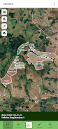
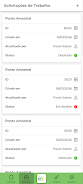
The core of Agrotti is an interactive mapping and analysis workspace that turns raw field observations and satellite imagery into actionable recommendations. Users can import or view georeferenced data, overlay remote sensing indices, and run geostatistical assessments to identify zones of differing productivity. The system produces spatial recommendations that help prioritize sampling, adjust fertilizer placement and monitor treated areas across time.
Controls and interaction
Interaction is optimized for touch devices: pinch-to-zoom, two-finger pan and long-press to inspect a point are standard controls. Layer controls allow toggling satellite imagery, normalized difference indices and productivity maps, while measurement tools let you draw boundaries, calculate area and extract zonal statistics. A guided workflow walks new users through project setup, mapping, sampling campaigns and interpreting recommendations so the app remains accessible to technicians and producers with varied technical backgrounds.
Progression and project workflow
Progression in Agrotti is project-centered rather than game-like: you create a field project, define parcels, collect or upload sampling points and then move through analysis stages. Each stage builds on the last—data validation, spatial interpolation, recommendation generation and monitoring—so users see clear steps that improve decision quality as more data are added. Seasonal progression is supported by comparing historical layers and updating recommendations as new harvest or sensor data become available.
Visual style and level structure
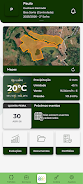
Maps use clear, color-coded visualizations to represent variability: heatmaps and choropleth-style layers indicate zones of low, medium and high productivity or nutrient levels. Tile-based rendering keeps navigation smooth at different zoom levels, from whole-farm overviews down to subfield management zones. Legends and contextual pop-ups explain colors and statistics so technicians can confidently present results to producers in the field.
Customization and reports
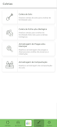
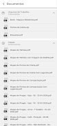
Users can customize thresholds, zoning rules and the parameters used in geostatistical interpolation to match local agronomic practice. Agrotti supports exporting maps and tabular reports for farm records or advisory reports, enabling technicians to communicate recommendations and keep audit trails of decisions. Export formats and simple summaries are oriented to practical use rather than technical jargon.
Replay value and iterative use
The app’s value increases with repeated use: revisiting fields across seasons makes it possible to track the impact of interventions and refine management zones. Scenario comparisons let users test different input distribution strategies on historical data and observe how small changes affect spatial variability. This iterative process strengthens recommendations and delivers a measurable path toward higher efficiency and profitability.
User experience and accessibility
Agrotti emphasizes readability and ease of use with clean typography, a logical layout and color palettes that consider common forms of color blindness. Contextual help and tooltips are available for most controls. The interface is designed for field conditions—large touch targets and minimal menus—so technicians can work efficiently while on site. The app requires a relatively modern Android device (minimum 4GB RAM, octa-core processor and Android 9.0+), and performance optimizations help on mid-range hardware.
Offline play and data quality
To support remote work, Agrotti includes offline caching for recently used map tiles and field data so users can continue analysis without a live connection and synchronize updates when connectivity is restored. Built-in data quality indicators flag outliers, missing coordinates or inconsistent sampling so users can address errors before running spatial models. These safeguards help ensure recommendations are based on reliable inputs.
Challenge systems and limitations
Rather than gamified challenges, Agrotti provides operational alerts and quality-control tasks that act as situational challenges: calibrate sensors, re-sample suspicious points or confirm boundary edits. The app is limited to Agrotti clients and is intended for professional advisory and farm management contexts; it does not include public multiplayer or ranking systems. For support and continued development, Agrotti is maintained by a team focused on soil fertility management and plant nutrition, combining field experience with precision agriculture research to deliver practical, science-backed tools for Brazilian agriculture and similar production systems.
- No virus
- No advertising
- User protection
Information
- File size: 67.76 M
- Language: English
- Latest Version: 1.0.1
- Requirements: Android
- Votes: 290
- Package ID: br.com.geodata.agrotti
- Developer: Agricultura de Informação
Screenshots
-
1

WhatsApp Business Mod
Download -
2

ChatOn – AI Chat Bot Assistant Mod
Download -
3

4English - Learn English Daily Mod
Download -
4

Any.do - To do list & Calendar Mod
Download -
5

Habitify: Daily Habit Tracker Mod
Download -
6

ANDI - Ai Search Engine
Download -
7

GitMind: AI Mind Map, Chatbot
Download -
8

ELSA AI Learn & Speak English
Download


Explore More
Discover and download the latest system software of 2024 at high speed for free. Explore multidimensional rankings and references to help you choose the best system software. Rest assured, all software has undergone rigorous security checks and virus scans for your safety.

Chinese cooking recipes game
Time Sphere

Parallel

AirConsole

PicklePlay

Moonlight

Monitora View

Arise