Introduction
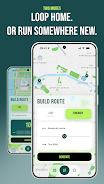
RunninParis is a specialized route-building app that helps runners explore Paris with AI-powered route generation, producing loop or point-to-point itineraries tailored to your pace, comfort and scenery preferences. With RunninParis you can enter an address, select Loop or Itinerary mode and receive suggestions that take sidewalk width, tree cover, pedestrian zones and park locations into account, all scored using official Paris open datasets. The app is designed for both locals who want fresh routes and visitors who want a guided city exploration, and it supports exporting GPX files so routes can be transferred to watches and third-party fitness apps.
Key features
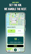
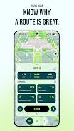
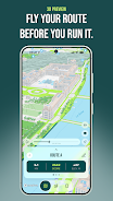
RunninParis combines an intelligent route builder with data-driven scoring to help you choose runs that fit your priorities. The core generator uses AI to assemble routes from the city network and ranks options by comfort and scenery using up-to-date municipal datasets on sidewalk width, green cover and pedestrianized streets. Choose between short recovery loops, scenic tours that favor tree-lined streets and park segments, or point-to-point itineraries that lead you to a particular landmark. Routes can be previewed in a 3D fly-through, saved to your personal library, compared side-by-side by score, and exported as GPX files for offline navigation on compatible devices.
Controls and user interaction
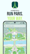
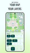
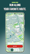
The app interface is built for quick route creation with minimal inputs: type or pin an address, pick Loop or Itinerary, set a distance range and prioritize factors such as sidewalk width or green cover. Sliders and toggles control these preferences so the route generator adapts to your chosen balance of safety, scenery and directness. Map controls let you switch themes, toggle overlays for amenities and pedestrian zones, zoom through a 3D preview and inspect turn details before exporting. Running Mode is a pared-down view that displays a live blue dot, distance, pace and remaining route without unnecessary clutter to keep your focus on the run.
Progression and personalization
There is a practical progression built around building a personal route library: save favorites, annotate them with notes or tags, and use side-by-side comparisons to refine what matters most to you. Over time you can curate a set of routes for easy weekday workouts, long weekend runs or scenic tours for visitors. Preference presets help the generator produce suggestions consistent with your goals—whether that’s maximizing tree canopy, avoiding busy sidewalks or prioritizing continuous park segments—so the app becomes faster to use as your library grows.
Visual style and map design
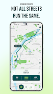
The running map is optimized for outdoor exercise with clear typography, contrast-friendly color themes and runner-focused overlays such as park boundaries, pedestrian zones and sidewalk width shading. A 3D preview mode provides an aerial fly-through so you can visualize elevation changes and urban context before heading out. Running Mode simplifies the visual design further, presenting only essential elements like the active route line, your real-time position and simple pace/distance readouts to reduce distraction while you run.
Replay value and challenge systems
Replay value comes from the combinational possibilities of start points, distance ranges and priority settings: even familiar neighborhoods can produce new, interesting loops when you change the emphasis from directness to scenery or from flat routes to ones that include parks and bridges. Custom challenge settings let you request longer distances or continuous green-space segments to create endurance or tempo-focused outings. Because the route engine generates multiple scored alternatives, you can run a different high-scoring option each week without repeating the exact same path.
Accessibility and offline use
RunninParis includes accessibility-minded touches such as larger touch targets, high-contrast theme options and a simplified Running Mode to improve readability on the move. Saved routes and exported GPX files make it practical to use routes offline: export a GPX before leaving Wi-Fi and import it into a compatible watch or mapping app to follow the route without a persistent connection. Note that live map tiles and some preview features require an internet connection, while saved route files and the basic Running Mode continue to function with GPS available.
Limitations and practical notes
The app focuses exclusively on Paris: its scoring and datasets are specific to the city and do not apply outside the municipal area. Turn-by-turn navigation on watches or third-party navigation apps requires exporting GPX files rather than direct watch integration. Finally, Running Mode depends on reliable GPS signal for accurate real-time tracking, so dense urban canyons or tunnels may affect the live blue dot and pace readings.
- No virus
- No advertising
- User protection
Information
- File size: 79.91 M
- Language: English
- Latest Version: 1.1.0
- Requirements: Android
- Votes: 321
- Package ID: com.runninparis.app
- Developer: Luca Perrin
Screenshots
-
1

Windy.app - Enhanced forecast
Download -
2

Wink – Video Enhancing Tool Mod
Download -
3

AI Chat Smith Open Chatbot 4 Mod
Download -
4

Vidmix - AI Art & MV Maker Mod
Download -
5

GoDaddy Studio: Graphic Design Mod
Download -
6

Video Editor & Maker- My Movie Mod
Download -
7

StoryArt - Insta story maker Mod
Download -
8

Storytel: Audiobooks & Ebooks Mod
Download


Explore More
The Map Navigation Software Collection features a wide range of navigation apps, addressing the issue of friends being unsure of their way when heading out. These apps provide precise navigation for users and adjust routes based on real-time traffic conditions to ensure users reach their destination quickly.

Chinese cooking recipes game
Time Sphere

Bruh Sound Button

PicklePlay

TruckTap

PIB JANDIRA

Remote Control for TV

НейроЧат