Introduction
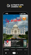
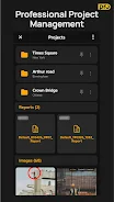
Ultimate GPS Camera Pro is a GPS map camera and geo-tagging tool that helps professionals capture field photos with location and time data embedded directly onto images. The app combines automatic geotagging, customizable geo-card templates, map overlays and timestamps so you can document sites faster and more reliably. It also creates PDF reports and organizes images by project for quick retrieval, making it useful for construction, real estate, engineering, surveying and site inspections.
Key Features
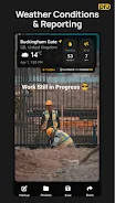
In Ultimate GPS Camera Pro advanced geotagging automatically adds latitude, longitude, altitude and compass heading to each photo. Custom geo-card templates provide a range of professional layouts that can include weather, map snippets and address details. The app generates PDF reports with embedded location data, supports folder-style project organization, allows image markups for notes and drawings, and offers cloud backup plus multiple map styles such as satellite, terrain and hybrid.
Advantages
Ultimate GPS Camera Pro saves time by automating GPS stamping, timestamps and map overlays, reducing the need for manual editing. It improves field documentation accuracy and creates verifiable photo records for reports and inspections. Project templates and folder-based management help keep work organized, while quick PDF generation makes it easier to share consistent information with teams and clients.
Disadvantages
The app requires camera and location permissions to capture geotagged photos and overlays. GPS accuracy depends on the device and local signal conditions, so coordinates can vary by environment. Some advanced settings and template customizations may require initial setup time to match specific workflows.
- No virus
- No advertising
- User protection
Information
- File size: 113.59 M
- Language: English
- Latest Version: 1.8.1
- Requirements: Android
- Votes: 212
- Package ID: com.ultimategpscamera.pro
- Developer: Pravin Gasva
Screenshots


Explore More
Explore the Latest Free Downloads of Top Photo Apps in 2024, Featuring Multi-Dimensional App Rankings and Recommendations for the Best Photo Applications. All apps are virus-free, safe and secure for your peace of mind.

Chennai Super Kings
Fruits and Vegetables for Kids

TriviaMaker

HTC Net

Prophecology

PearDrop

Cultura y Turismo Qro

Remote Control for TV