

Introduction
Stay updated on wildfire and prescribed burn activity worldwide with Wildfire Info. It provides real-time data sourced from various dependable sources like WFIGS, NASA, EPA AirNow, InciWeb, CAL FIRE, and more. You can easily browse and search for active wildfires by state or name, and even filter them by the number of acres burned. The app also features thermal hotspot maps generated by NASA's MODIS and VIIRS satellite instruments, giving you insights into the intensity and scale of wildfires. Additionally, it provides air quality data globally, detailed weather conditions, and links to official incident webpages, ensuring you have all the necessary information at your fingertips to stay informed and prepared.
Features of Wildfire Info:
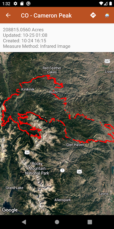
⭐️ Browse current wildfire and prescribed burn activity worldwide: Users can easily access information about ongoing wildfires and prescribed burn activities from all over the world.
⭐️ Detailed and real-time data: The app provides accurate and updated information on wildfire perimeter data, including state tagging, name search, and filter options based on acres burned. Data is refreshed every 20 minutes.
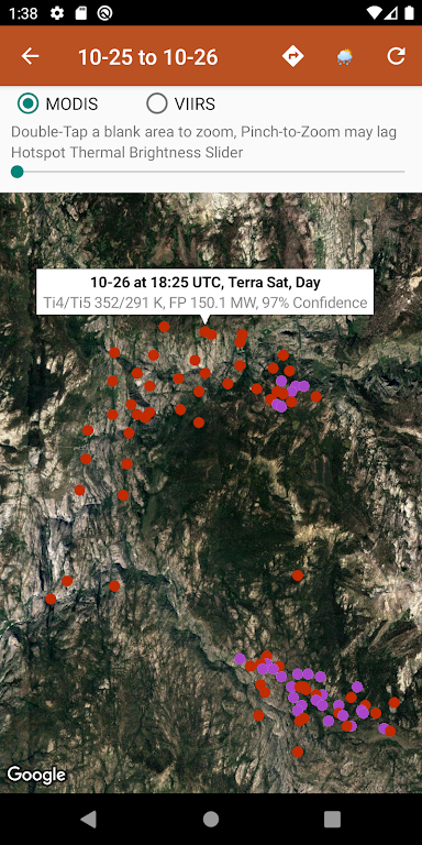
⭐️ Satellite instrument data: Users can view thermal hotspot maps generated by NASA MODIS and VIIRS satellite instruments. These maps show wildfire activity in the past 48 hours and provide additional details such as fire radiance power, brightness temperature, and confidence.
⭐️ Global air quality data: The app offers air quality data globally, including PM2.5 PM10 and Ozone levels. The data is sourced from reputable authorities like EPA AirNow and PurpleAir.
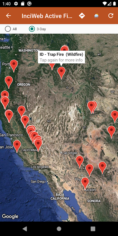
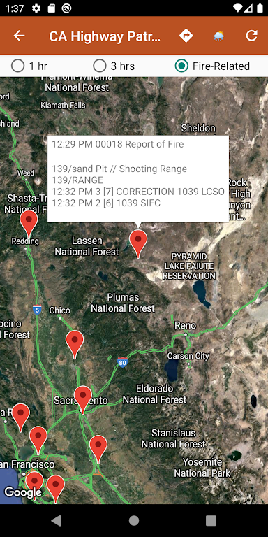
⭐️ Integration with official resources: Users can access active fire maps from InciWeb and CAL FIRE, with direct links to the corresponding official incident webpages. This integration ensures users get reliable and authenticated information.
⭐️ Weather information: The app provides hyper-local weather summaries sourced from NWS, NOAA, Government of Canada, and Government of Australia. Users can check temperature, wind and gust conditions, and local forecasts anywhere in the USA, Canada, or Australia based on their map location.
Conclusion:
Stay informed and prepared for wildfires with Wildfire Info. Browse global wildfire activity, access real-time data from satellite instruments, and monitor air quality worldwide. Get reliable information from official sources such as InciWeb and CAL FIRE. Additionally, stay updated on hyper-local weather conditions and forecasts. Download the app now to protect yourself and your community from the dangers of wildfires.
- No virus
- No advertising
- User protection
Information
- File size: 23.34 M
- Language: English
- Latest Version: 3.0
- Requirements: Android
- Votes: 356
- Package ID: com.davidgrossapps.wildfire
- Developer: David Gross Apps
Screenshots
-
1

Windy.app - Enhanced forecast
Download -
2

Wink – Video Enhancing Tool Mod
Download -
3

AI Chat Smith Open Chatbot 4 Mod
Download -
4

Vidmix - AI Art & MV Maker Mod
Download -
5

GoDaddy Studio: Graphic Design Mod
Download -
6

Video Editor & Maker- My Movie Mod
Download -
7

StoryArt - Insta story maker Mod
Download -
8

Storytel: Audiobooks & Ebooks Mod
Download


Explore More
Dating software is a type of software that is very popular among single users. Are you lonely when you are still single? Have you ever thought about dating a girl/boy? There are some of the most popular dating apps, which can help singles no longer worry about finding a partner. What are you still hesitating about? Come and download!

WordFinder

Forescore

Lama—Game & Voice Chat

PicklePlay

Billcast

Moonlight

Teamsprojects

Monitora View
You May Also Like


Comment
-
Fine app but i could just look up the same info on google and save me the space on my phone.2024-05-15 11:24:17
-
Never has worked. Forced closes on app activation.2024-05-14 16:53:30
-
Doesn't follow Calfire fires properly. Doesn't show the current fire situation or status. Garbage.2024-05-13 14:04:19
-
No problems (just downloaded 15 minutes ago). Wish I had found this app sooner.2024-05-13 09:38:22
-
It would also be good if our location is displayed on the map. Thanks for the update.2024-05-13 08:37:35
-
App crashes immediately and continues to crash.2024-05-12 05:55:09